Map Anavasi Macedonia 1:230.000
Payment and receive from store.
Cash on delivery of the order at your place with the cooperating company +additional cost ELTA courier 2 €
Credit Card / Debit Card Payment:
The online store Freerider.gr accepts all Visa, Mastercard credit cards through the Eurobank system and the possibility of using 3 interest-free installments for purchases above € 50 and 6 for purchases above € 200.
All the conditions for maximum data security provided by law are met.
IRIS online payment
Payment via PayPal:
Now at Freerider. gr you can make your purchases easily, quickly, and securely through PayPal.

Payment via tbi bank:
Buy now, pay later. Flexible payments that suit your needs 100% online and no credit card is required
By depositing in a bank account:
Prepay your order in one of the following bank accounts we work with:
NATIONAL BANK: 15050005139, IBAN: GR3301101500000015050005139
EUROBANK: 0026.0058.16.0200337707, IBAN: GR1902600580000160200337707
ALPHA BANK: 137002320002790, IBAN: GR7101401370137002320002790
PIRAEUS: 5035-075528-805, IBAN: GR1401720350005035075528805
Beneficiary: SIDERIS I. EMMANOUIL
Please, send us a copy of the bank payment order, wiht your Last/First name and the number of the order at info@freerider.gr
Also consider, there are bank fees between transfers to other banks that always charge consumers.
Be sure that you had paid the whole bank fee amount - your order will not be able to be dispatched if there is a financial difference.
The order will be able to be executed upon we will see the deposit on our Bank account - with a value date of one business day for EUR payments (D+1) and two business days for payments in other currencies (D+2), provided your order is submitted during business days from 8:00 to 16:00.
Order Completion:
As soon as your order is completed, a confirmation email with the details of your order is automatically sent to you. Regardless of the payment method for your order, our company will contact you by phone as soon as possible for final confirmation.
Shipping Method:
- Shipments are carried out by the companies BOX NOW, ELTA COURIER and XP COURIER.
- Pickup from our headquarters at Ifigenias 36 in Neo Irakleio, Attica is also available.
Free Shipping to Anywhere in Greece:
For orders over €79, shipping costs are free provided that the weight of the products does not exceed 5 kilograms (actual weight in kilograms or volumetric weight LENGTH x WIDTH x HEIGHT).
Shipping costs for orders over €79 and over 5 kilograms are subsidized.
*For shipments with XP COURIER , free shipping does not apply.
Blue® | Guaranteed Next Business
Day Delivery
Receive your order the next business day, exclusively for ATTICA (based on postal code):
• Shipments up to 5 kg: 4,7€
• Shipments 6-10 kg: 8€
• Over 10 kg: 0.80€/kg
Payment Methods: Cash on Delivery (+2€), Bank Deposit, Iris, Credit Card.
*The above prices include
Gold® | Guaranteed Same-Day Delivery
Receive your order on the same day, exclusively for ATTICA
(The service is available in selected areas, depending on the postal code):
• Shipments up to 5 kg: 5.00€
• Shipments 6-10 kg: 7.50€
• Over 10 kg: 0,75€/kg
Payment Methods: Iris, Credit Card.
Delivery Hours: 16:30 - 21:00
*The above prices include VAT.

Shipping with Box Now:
Our orders are also shipped with the company Box Now to areas where the company's lockers are available.
- For mainland Greece, your order will be available for pickup on the next working day at a time that suits you, from the locker you have selected.
- The shipping cost is €2.40 (VAT included).
- A basic requirement for shipping your order with Box Now is that the package does not exceed the following dimensions: Length ≤ 44cm, Width ≤ 60cm, Height ≤ 35cm (including packaging material).
- Cash on delivery payment method is not supported.

Shipping with ELTA Courier:
Shipping Costs for orders below €79 or over 5 kilograms:
- For areas outside Attica:
ELTA Courier: 0-5 kg €3.50 / 6-10 kg €6.00 / 11-20 kg €9.00, + €0.75 for each additional kilogram.
- For Attica:
ELTA Courier: 0-5 kg €3.00 / 6-10 kg €5.50 / 11-20 kg €8.00, + €0.75 for each additional kilogram. Delivery time is from 3 to 10 working days.
The above prices include VAT.
Shipping Costs for orders with payment via bank deposit and prepayment via credit card:
Same as above.
Cash on Delivery Nationwide:
Payment upon delivery of your order to your location with our cooperating company ELTA Courier at a cost of €2.00 for using the service.
Calculation of Weight:
If the volumetric result of the shipment (LENGTH x HEIGHT x WIDTH in centimeters / 5000) is greater than its actual weight, the charge is based on the volumetric result.
Delivery Delay:
In case your order is not delivered within the specified time mentioned above, please contact us.
Contact phone number: 2102723936
email: info@freerider.gr
Product returns are made if the following conditions apply:
The purchase must have been made within Greece.
Presentation of purchase receipt (receipt, purchase invoice)
The products must be in their original packaging (box, jelly, labels, etc.).
The products must be in perfect condition and the product has not been used.
There must have been prior consultation with our store.
It should not be more than 14 days since the purchase of the goods.
No refunds will be made on items purchased on special offer.
Return costs are borne by you if it is a purchase withdrawal
The following products are not returned: Underwear, swimwear - bottom, socks.
No refunds for in-store purchases.
Free cost Change ( only for Greece ):
The first Change (regarding return and reshipment cost) is free of charge for purchases from our online store, provided that you use the ELTA Courier or BoxNow shipping company.
In case of shipping with another courier company, the costs are borne by you.
Refunds for remote purchases:
The consumer has a period of fourteen calendar days to retire, if he has made purchases remotely, without stating the reasons and with the sole charge of the cost of returning the product. The supplier, for his part, must refund the amount including shipping costs - but not the charge for cash on delivery.
Before making any return of the product, make sure that 14 calendar days have not elapsed from the date of receipt of the product and fill in the returning form which is included the dispatched order.
The consumer is responsible for any reduction in the value of the product only if he misused it.
Once we receive the product and your return is approved, the refund process can be completed within 14 days from the date we receive the returned products. If the payment was made by you via Pay Pal or by Credit Card then the refund will be made accordingly. If you have paid by cash on delivery, please fill in your account details in the appropriate fields so that your bank account can be can be credited .
Defective products:
In addition to the above rights, the buyer, in case of a product that has a defect or lack of agreed quality, has all the rights from the existing provisions and laws regarding the contract of sale and protection of the consumer.
How to send products to our company when the charge is borne by us:
1.ELTA Courier call at 11120 and send the parcel to the following address with recipient charge. (In case of shipment with another courier company, the costs are borne by you).
Shipping to: SIDERIS EMMANOUIL, recipient code 219399, Ifigenias 36a, Zip Code 14122, Heraklion, Attica, Telephone: 210 2202196
2. With BoxNow, place the package in any ΒοχNow locker, entering the tracking number of the package you received - be careful not the pin code sent to you by the courier.
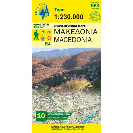
Map Anavasi Macedonia 1:230.000
The road map of Macedonial on a scale of 1:230.000, covers the entire region of Macedonia from the Pindus mountain range to the Nestos river. The map depicts the topography with a coloured shaded relief, the new administrative divisions, new roads, settlements, monuments and major place-names, national parks, ski resorts, mountain refuges, the course of the European paths E4 and E6, and wineries that are open to the public. Contact details of the wineries are included in the booklet, along with the settlements index.On the side of the map selected nature escapes are presented
Year: 2019
Scale: 1:230.000


